
The Geographical Imagination
Updated 17 February, 2024
Understanding how we imagine a place is an important part of Geography, but not in the way you might think
Attempt to view the world in a completely different light. Rebel against your geography teacher by challenging their preconceptions. Re-evaluate the familiar, and reimagine the planet by rejecting the way it has been portrayed by the mainstream geographical imagination.
Take a look at the map below - it all looks very wrong.
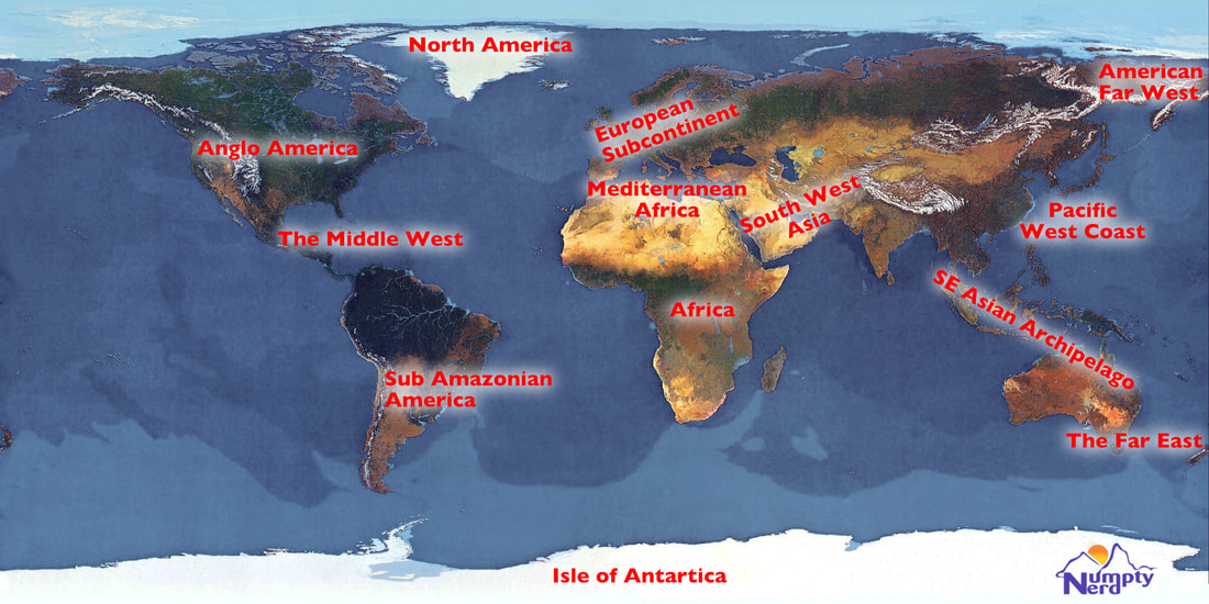
The Far East
New Zealand and much of Australia is further east than Bangkok and many other places that most people would consider to be 'out in the Far East'. Why do we generally not imagine Australians as being Oriental? Could Hawaii be imagined to be in the Far East?
Pacific West Coast
Makes you think of California, so they call it Asia-Pacific to stop your brain hurting. Ask someone if Japan is located on the western or eastern Pacific and see what happens.
The Middle West
Makes about as much sense as "The Middle East". The Caribbean is in the western hemisphere and is located in the middle of the two Americas. Should we refer to this area of the world as being part of the Occident? Occident suggests west in much the same way as Orient means east.
South West Asia
If it's okay to say southeast Asia then why do people refrain from referring to southwest Asia? Asia has four corners, but some only know of the one. The Middle East - it's in the middle of what and east of where? Forget the Eurovision Song Contest, Israel is in southwest Asia, not Europe.
Anglo America
A parody of Latin America. Quechua, Guarani, English, and Dutch are all spoken in "Latin America". Indeed, there are several languages in South America that are not especially Latin in origin. Likewise, Anglo America is a label that is unlikely to be popular with French or Hispanic speaking North Americans.
North America
Greenland is a part of the North American plate, yet rarely gets recognised as such. The World's biggest island is truly American, not Australian. Some people imagine Greenland to be European. Ask people to name the countries of North America and see what happens. Where do you imagine Mexico to be?
American Far West
If you look at a map showing geological plate boundaries, you can see that much of Siberia is on the North American plate. In the unlikely event of sea levels dropping, The Bering Strait would disappear and so change our perception of the Asian-American boundary. Armed with this information, could we imagine Siberia as being North American?
Sub-Amazonian America
The lands south of the Amazon rainforest. Just as valid as Sub-Saharan Africa - the lands south of a big biome. With the decline of the rainforest, you're stuck with imaginations of a Latin America.
European Subcontinent
When it comes to subcontinents, India seems to have a monopoly. How many other subcontinents are used in common parlance? Europe is just a small chunk of land stuck onto Asia - get over it!
Africa
Often imagined to be a country.
Mediterranean Africa
Many call it The Maghreb. When western people think of the lands of the Mediterranean, some only seem to think of Europe and forget that this sea has a south coast. For example, the "Mediterranean Diet" is often imagined to be European, not African.
Isle of Antarctica
Some have imagined Australia to be the world's largest island, yet the "Isle of Antarctica" is about 14 million square kilometres in size, making it much larger than Australia, which is around 7.7 million square kilometres. The rebellious among us might want to imagine Australia as just another island, part of the archipelagos of Southeast Asia.
The Geographical Imagination
The geographical imagination refers to the ways in which people conceive of and understand the world around them, including the physical layout of the land, the nature of places and the relationships between them. This concept is not solely a personal or individual creation; it is significantly shaped by various external factors and actors, including powerful individuals and institutions.
Media
- Representation in News and Entertainment: How places are portrayed in movies, television shows and news media can deeply influence people's perceptions, often propagating stereotypes or highlighting certain characteristics while omitting others.
- Cartography Choices: The design of maps, including what is included or excluded and how areas are proportioned (like the Mercator projection exaggerating the size of the northern hemisphere), reflects the cartographer's biases and can shape viewers' understanding of the world.
Education
- Curriculum: Educational content, such as textbooks and teaching materials, often reflects the perspectives of those in power, shaping students' understanding of geography, history and culture.
- Language: The language used to describe places and people can carry value judgements and shape the way those places and people are imagined.
Political Influence
- Nationalism: Governments often promote a certain image of the country to foster national identity, which can influence citizens' geographical imagination.
- Territorial Disputes: Political leaders may emphasise certain territorial claims or historical narratives to justify political goals, influencing public perception of geography.
Economic Factors
- Tourism Campaigns: Promotional materials designed to attract tourists often present an idealised, sometimes unrealistic, image of a location.
- Corporate Influence: Businesses and advertisers often highlight certain geographical features or locations to align with their brand or to sell products, influencing consumer perceptions.
Cultural Production and Discourse
- Literature and Art: Works of art and literature often convey powerful images of place that can become ingrained in the public imagination.
- Public Discourse: Influential figures can shape geographical imagination through speeches, writings and public appearances.
Technological Mediation
- Internet and Social Media: Algorithms and platforms can prioritise certain types of content, locations and narratives over others, affecting what people see and learn about the world.
- Virtual and Augmented Reality: These technologies can create immersive experiences of places that might be geographically distant or imaginary, influencing one's spatial perception and understanding.
Case study: London Olympic Games
|
The opening ceremony of the 2012 London Olympics featured a cameo appearance by James Bond (played by Daniel Craig) alongside Queen Elizabeth II. For non-British viewers, this may have seemed like an unusual pairing of a fictional spy character with the real British head of state.
The clip of their interaction, complete with cute corgis, proved wildly popular on YouTube with over 68 million views. This signalled how effectively it captured certain aspects of British culture and national pride. While the specifics may not resonate globally, showing the scene to a British person reveals the swell of patriotic emotion it can elicit. Their reaction underscores how cultural symbols and historical references can act as powerful forces that help to construct the geographical imagination. Controversially, the inclusion of "The Dam Busters" theme song also reflected how some facets of Britishness still relate to nostalgia for achievements in wartime. However, such nostalgia may not translate for audiences beyond the UK. Vertical Divider
|
How did the 2012 London Olympic Games help construct the British geographical imagination? |
If you have made it this far, you might be looking for a more academic insight into what geographers have said about the geographical imagination. Below, is a summary of a handful of writers whose work has helped us understand how we imagine places to be.
Edward Said and Benedict Anderson have famously advanced the concept of "Geographical Imagination." Said has exposed the West's stereotyping of the East as an exotic, less advanced 'Orient' (Said, 1978; 1995). He argues that such views, depicting Islamic populations as uncivilised, stem from colonialist attitudes. Anderson examines how imagination underpins our concepts of nationhood, suggesting that nations are more than physical spaces—they are formed by shared experiences, language, and media (Anderson, 1983). He argues that since we cannot know every individual within a country, we rely on imagined constructs, often derived from media, to form our ideas of national and global societies.
The Humanist Geographer, Yi-Fu Tuan
Yi-Fu Tuan sought to bring a more humanistic approach to geography. He focused on how individuals experience and engage with their surroundings (Tuan, 1977). Tuan was interested in topics such as how people form attachments to place and how landscapes hold symbolic meaning (Tuan, 1979). His work highlighted the subjective meanings that different spaces can hold for varied individuals and groups (Tuan, 2001). This human-centric perspective reshaped the geographical imagination to consider personal experience and perception of the environment (Tuan, 2004).
The Poststructuralist Geographer, David Ley
David Ley explored how we can deconstruct many of the taken-for-granted categories with which we perceive and analyse the world (Ley, 1995). Ley showed interest in topics such as how discourses shape understandings of places (Ley, 2004) and how fluid notions of identity can be (Ley, 2003). His poststructuralist leaning emphasised the socially constructed nature of spatial frameworks (Ley, 2000) and challenged the idea of objective or essentialist classifications of landscape (Ley, 1998). Ley revolutionised geographical thought by bringing theory to the fore (Ley, 2017) and prompting considerations of power in the production of geographical knowledge (Ley, 2012).
The Marxist Geographer, David Harvey
David Harvey focused on the relationships between spatial organisation and capital accumulation (Harvey, 1982). He viewed urban process as being driven by the imperatives of capital investment and profit maximisation (Harvey, 2006). Harvey was keen to demonstrate how the urban landscape is moulded to suit the needs and logic of capitalistic systems (Harvey, 2010). Harvey imbued geography with Marxist undertones and placed economic factors at the heart of imaginations of the urban environment (Harvey, 2008). He considerably politicised the geographical imagination and placed class struggles and issues of ownership at the forefront of analysis (Harvey, 2013).